Rare Devices for Ice Structure Research in the Arctic: How Technology is Helping to Study Climate Change

Rare Devices for Ice Structure Research in the Arctic: How Technology is Helping to Study Climate Change

The Arctic, a region that has become the focal point of climate change research, offers a unique and challenging environment for scientists seeking to understand the dynamics of our planet’s frozen landscapes. The Arctic ice sheets and glaciers are sensitive indicators of global climate changes, and their degradation has profound implications for rising sea levels and global weather patterns. To investigate these changes, scientists rely on advanced technologies and specialized devices—some of which are rare and highly sophisticated—designed to study the structure of ice in ways that were once unimaginable.

The Importance of Studying Ice in the Arctic

The ice sheets of the Arctic hold critical information about the Earth's climate history. Ice cores—samples of ice drilled from deep within glaciers and ice caps—contain trapped air bubbles, mineral particles, and other environmental records that provide a detailed archive of atmospheric conditions over millennia. By studying these cores, researchers can reconstruct past climates, track changes in atmospheric gases, and even understand the mechanisms that have led to past periods of global warming and cooling.

However, understanding the complex interactions between ice, air, and ocean currents requires more than just traditional ice core sampling. It demands the use of rare and specialized devices that can probe the ice’s structure and monitor ongoing changes. Technologies such as remote sensing instruments, ground-penetrating radar, and autonomous underwater vehicles are just a few examples of the cutting-edge tools being used in the Arctic today.

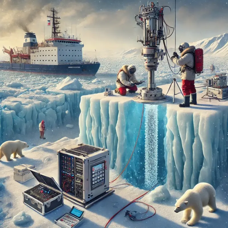
Ice Core Drilling and Analysis

One of the most common and valuable techniques used in Arctic ice research is ice core drilling. This process involves extracting long cylinders of ice from glaciers or ice sheets, which are then carefully analyzed for trapped gases, dust particles, and other microscopic indicators of past climate conditions. The study of ice cores has provided some of the most significant revelations about Earth’s history, including evidence of natural climate cycles and the impact of human activity on global warming.

However, extracting ice cores in the Arctic is not a straightforward task. The region’s extreme cold and remote location pose significant logistical challenges, requiring specialized drilling equipment and methods. In recent years, researchers have used advanced drilling rigs that can operate at depths of several kilometers, reaching ice that has been frozen for hundreds of thousands of years. Some of these drilling rigs are rare and require substantial expertise to operate, making them invaluable tools in the study of Arctic ice.

In addition to conventional drilling, scientists have developed new techniques for collecting ice core samples from particularly hard-to-reach areas. For example, specialized drill bits equipped with heating elements can melt through thick layers of ice, allowing researchers to collect samples from otherwise inaccessible regions. This approach is especially useful for studying the ice that forms at the interface between the ice sheet and the underlying bedrock, as these layers are often key to understanding the flow dynamics of glaciers.

Remote Sensing and Satellites: Eyes from Above

While ice core drilling provides direct data from the ice itself, remote sensing technologies enable scientists to monitor ice sheets from afar, offering a broader perspective on changes across vast areas of the Arctic. Satellites, in particular, have become indispensable tools for studying polar regions. Instruments aboard satellites, such as altimeters and radar systems, allow scientists to measure changes in ice thickness, surface elevation, and even the velocity of glaciers.

For example, the European Space Agency’s CryoSat-2 satellite, launched in 2010, uses radar to measure the thickness of polar ice caps with remarkable precision. This satellite’s measurements are crucial for tracking the melting and thinning of ice in the Arctic and Antarctic regions. Remote sensing has also made it possible to map the extent of ice cover in real-time, providing valuable insights into seasonal variations and long-term trends.

In addition to satellites, drones have emerged as another powerful tool for Arctic research. These unmanned aerial vehicles (UAVs) are equipped with high-resolution cameras and sensors that can capture detailed images of ice surfaces and even penetrate through ice to reveal structural layers beneath. Drones can be deployed over vast stretches of ice, providing data in areas that would be difficult or dangerous for researchers to access directly.

Ground-Penetrating Radar: Seeing Below the Surface

One of the most innovative technologies used to study the structure of Arctic ice is ground-penetrating radar (GPR). GPR systems send radar waves into the ice, which then bounce back when they encounter different layers of ice or rock below. By analyzing the reflected waves, scientists can create detailed images of the ice’s internal structure, including the depth of the ice sheet, the thickness of ice layers, and the presence of water or air pockets beneath the surface.

This technology is particularly useful for studying the basal layers of ice sheets—the region where ice meets bedrock. These basal zones are crucial for understanding how glaciers move and behave, as they play a significant role in the dynamics of ice flow. GPR can also help identify areas where melting is occurring beneath the ice sheet, providing valuable information about the potential for ice shelf collapse and sea level rise.

Ground-penetrating radar systems are highly specialized and expensive, but they have revolutionized the way scientists study ice. In some cases, radar systems are mounted on vehicles that can travel across the surface of the ice, while in others, handheld GPR devices allow researchers to map ice thickness and structure at specific points. These devices can also be used in combination with other instruments, such as GPS systems, to create detailed, three-dimensional maps of ice dynamics.

Autonomous Underwater Vehicles (AUVs)

Another emerging technology for studying ice in the Arctic is the use of autonomous underwater vehicles (AUVs). These submersible robots are designed to navigate beneath the sea ice, providing valuable data about the interaction between ice sheets and the underlying ocean. AUVs are equipped with a range of sensors, including sonar, temperature probes, and salinity meters, which allow them to monitor the health of ice shelves and measure the temperature of ocean water below the ice.

These vehicles are particularly useful for studying the underside of ice shelves, where melting occurs as warm ocean water interacts with the ice. AUVs can collect data in remote areas where human researchers cannot go, and they can operate under thick ice cover for extended periods, making them indispensable for long-term monitoring.

The Role of Ice-Tethered Profilers (ITPs)

Another fascinating technology employed in Arctic ice research is the Ice-Tethered Profiler (ITP). These devices are autonomous, floating sensors tethered to the sea ice, which travel vertically through the ocean’s water column beneath the ice. ITPs are capable of continuously collecting data about temperature, salinity, and pressure as they move between the surface and the ocean floor. These profilers are particularly useful for studying the temperature gradients between the ice and the underlying ocean and can provide essential insights into the dynamics of ice melt at the base of ice shelves.

ITPs are often used in conjunction with AUVs and other instruments to offer a multi-dimensional view of how sea ice and the ocean interact. The data they collect is critical for understanding the role of ocean currents in accelerating ice melt, a phenomenon that has been identified as a significant contributor to the shrinking of Arctic ice.

The deployment of ITPs is not only limited to studying ice sheets and glaciers. These devices can also provide valuable information about the overall health of Arctic marine ecosystems, as changes in temperature and salinity can have a profound impact on marine life, including plankton, fish, and marine mammals. The ability to monitor these variables over time allows researchers to predict shifts in the Arctic’s complex food webs and identify areas of concern.

The Integration of Artificial Intelligence in Ice Research

While the technologies discussed above are crucial for gathering data, the analysis of this data has traditionally been a time-consuming process. In recent years, artificial intelligence (AI) and machine learning have emerged as essential tools in Arctic research. These technologies help process vast amounts of data collected by satellites, drones, sensors, and underwater vehicles.

AI algorithms are increasingly being used to identify patterns in climate data, predict ice sheet behavior, and improve ice core analysis. For instance, machine learning models can analyze ice core samples and detect minute changes in gas concentrations that might indicate subtle shifts in atmospheric conditions. In satellite-based remote sensing, AI can quickly identify areas of thinning ice, map ice flow velocities, and forecast potential future changes in ice dynamics. By automating data analysis, AI not only accelerates research but also helps scientists identify trends and correlations that might have gone unnoticed with traditional methods.

Furthermore, AI is also being utilized in climate modeling to predict the future impact of Arctic ice loss on global sea levels and weather patterns. These models combine data from various sources, including satellite images, ice core samples, and ocean temperature measurements, to simulate future climate scenarios. With the help of AI, scientists can better understand the potential consequences of melting ice, providing policymakers with more accurate predictions to inform decisions related to climate change mitigation and adaptation.

Advances in Ice-Penetrating Radar (IPR)

While ground-penetrating radar is crucial for studying ice layers, Ice-Penetrating Radar (IPR) represents an even more sophisticated version of the technology. IPR can be used to map subglacial environments in much greater detail, providing three-dimensional images of ice structures beneath the surface. This radar system can be mounted on aircraft or ground vehicles to scan through thick layers of ice and even map the flow dynamics beneath the glaciers.

One of the most exciting advancements in IPR technology is the ability to penetrate very thick ice sheets, even those in the remote Arctic regions. Using high-frequency electromagnetic waves, IPR can not only reveal the depth of ice and the conditions beneath it but also identify water and debris trapped within the ice. This is essential for understanding how ice sheets behave as they move, melt, or break off, which directly impacts global sea levels.

The ability to gather such precise and comprehensive data about ice structures has the potential to revolutionize our understanding of glacier dynamics. Researchers can now study the interaction between ice and bedrock with greater accuracy, providing critical insights into the processes that contribute to ice sheet stability or collapse.

The Collaboration of Global Research Efforts

Given the complexity of studying the Arctic and its rapidly changing environment, international collaboration is essential. Researchers and institutions from around the world are working together to develop and deploy these rare and cutting-edge devices, sharing data and findings to build a comprehensive picture of the Arctic’s ice systems. Collaborations between countries, universities, and research organizations help pool resources, expertise, and technology, enabling scientists to conduct more extensive and accurate studies.

For example, the International Arctic Science Committee (IASC) and other organizations coordinate large-scale research expeditions to the Arctic, where a wide range of instruments—including ice core drills, radar systems, and AUVs—are used in tandem to investigate the ice sheets. These joint efforts have led to groundbreaking discoveries, such as the accelerated melting of the Greenland ice sheet and the thinning of the Arctic sea ice, which are critical components of climate change research.

In addition to research expeditions, many nations have launched long-term observational programs in the Arctic, including year-round monitoring of ice conditions, atmospheric data, and ocean currents. These programs rely heavily on the deployment of rare and specialized equipment, which is often too expensive or logistically challenging for individual countries to operate on their own.

The Future of Arctic Ice Research

As climate change accelerates and the Arctic continues to warm at more than twice the global average, the need for innovative technologies to study ice dynamics will only increase. Advances in artificial intelligence, remote sensing, radar systems, and autonomous vehicles will continue to enhance our ability to monitor and understand the complex processes occurring in the Arctic.

New technologies, such as hyperspectral imaging and drone-based radar systems, are likely to offer even more detailed and efficient ways to map ice structures and monitor environmental changes. Furthermore, as our understanding of the Arctic’s role in global climate systems deepens, the continued development of specialized devices will play a critical role in shaping climate science, policy, and mitigation efforts.

The Arctic is often described as the "canary in the coal mine" of climate change, as it is one of the first regions to show the impacts of a warming planet. By leveraging rare and cutting-edge technologies, scientists can gain a better understanding of how these changes are unfolding and how they may affect ecosystems, weather patterns, and human societies around the world. In doing so, they are helping to create a more sustainable future for the planet.

Artykuły

Zarejestruj się do naszych powiadomień, aby otrzymywać najświeższe i najbardziej interesujące artykuły bezpośrednio na swoją pocztę!